Online Software to convert KML to CAD Drawing

kml


Google Earth implementation has brought in a new dimension for visualization. This created the opportunity for surveyors to present their data in Geographic Coordinate Systems. Mostly, surveyors display their information for clients with maps and two-dimensional graphics (Cartesian coordinate system), either on paper or digitally. With Google Earth there is a way to represent two-dimensional drawings to be shown in three dimensions, with an understandable backdrop of Earth Image. This has enabled surveyors a greater opportunity to impress clients and make it more understandable.

With simply powerful interface Google Earth combines and displays stunning graphics and a planet full of data to which anyone may add information and share that information with the rest of the world in just a few clicks. In a very short time Google Earth became very popular (More than 1 billion downloads) Because of its simplicity and power. It is simple to use yet highly stable.

Surveyors use Cartesian coordinates System (quadrant) to represent a point. Google earth on the other hand uses world geodetic system, WGS84 Map datum to represent data. To make survey drawings more accurate with respect to location, WGS 84, needs to be used while recording the field data.

You can mark locations & paths in Google Earth and save it as a KML file. These files cannot be opened in AutoCAD Directly, which works on Cartesian coordinate system. KML to CAD will convert all the point information present in KML that is Latitude Longitude to respective UTM (Universal Transverse Mercator) and prepares it as a DXF (Drawing Interchange Format, or Drawing Exchange Format) file which can be opened in CAD Packages like AutoCAD.

  1. How to convert KML to CAD Online?

    Once you are ready with input file. Login to www.esurveycad.com with your email id and respective password.

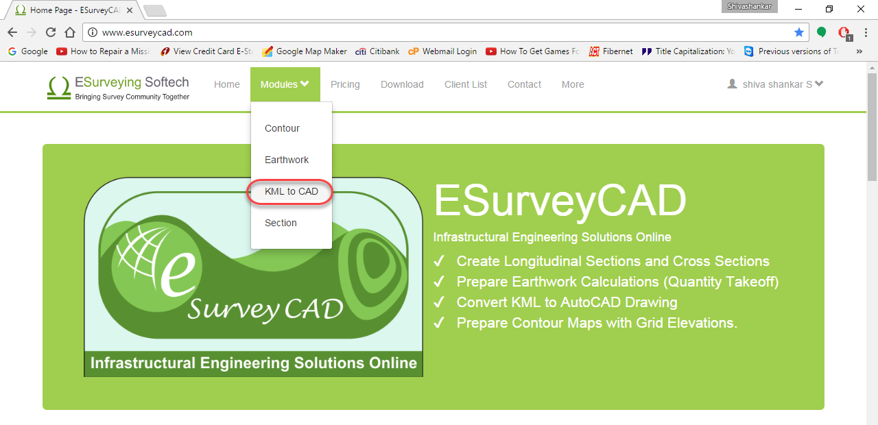
    1. Select KML to CAD option from Modules drop down menu.

      kml

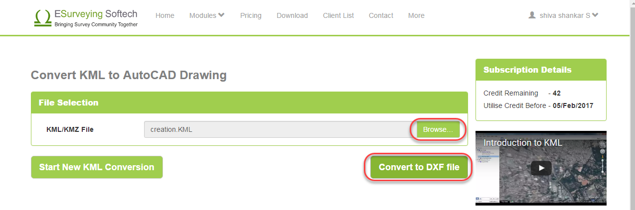
    2. Click on Browse button and select the KML or KMZ file to be converted. Then click on Convert to DXF file button. 

      kml

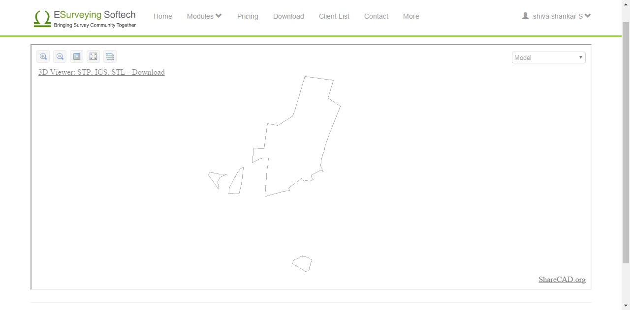
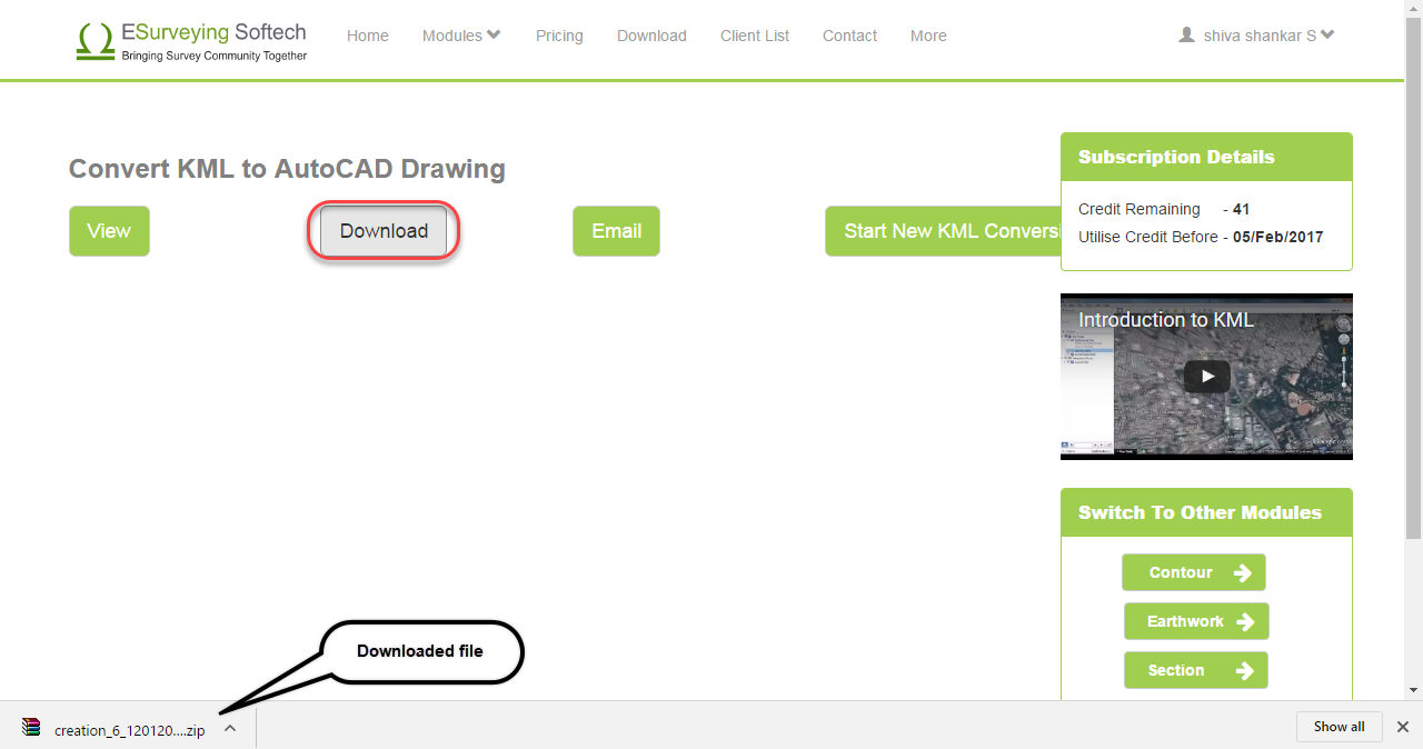
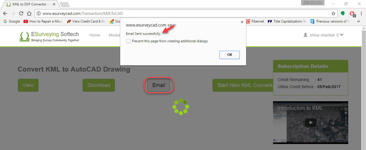
      Wait for a while and once the drawing is ready, software will show 3 more buttons on the top.

      kml

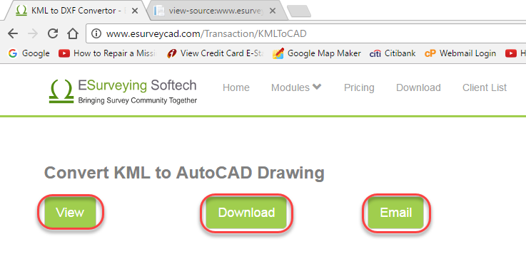
    3. Click on View button to immediately see the generated drawing.

      kml

    4. Click on the Download button, in case if you want to download the drawing

      kml

    5. Click on Email button, In case if you want to download the drawing later. When you chose this option, file link is emailed to you. Please note that you have to download the required file within 24 hours. Later these drawings are deleted forever from the application (Server).

      kml

  2. Know Software Limits

    The online application will convert any KML file of Less than 2 MB.

  3. Terminologies

    1. KML: KML (Keyhole Markup Language) is an XML based file format used to display geographic data in an Earth browser such as Google Earth, Google Maps, and Google Maps for mobile.

    1. KMZ: KMZ is a file extension for a place marker file used by Google Earth. KMZ stands for Keyhole Markup language Zipped. It is a compressed version of a KML (Keyhole Markup Language) file.

    1. DXF: AutoCAD DXF (Drawing Interchange Format, or Drawing Exchange Format) is a CAD data file format developed by Autodesk for enabling data interoperability between AutoCAD and other programs.

    1. DWG: These are the design file formats which can be directly opened in most of the Cad packages. The drawings prepared in this format are widely popular in almost all engineering and other domains also.

    1. UTM: The Universal Transverse Mercator (UTM) conformal projection uses a 2-dimensional Cartesian coordinate system to give locations on the surface of the Earth. Like the traditional method of latitude and longitude, The whole earth is not projected as UTM, instead it is divided into 60 zones(each zone being 6 degrees = about 800km) where Transverse Mercator(TM) is applied to reduce the distortion.

    1. LatLong: Latitude and longitudes (Latlong) is a traditional approach to identify or locate the point on a globe or a map. Latitudes are imaginary parallel lines (Circles) that run around the globe. These circles are just points at the poles. The longest latitude being the equator. Longitudes are the imaginary lines drawn from North pole to the South Pole. Greenwich line is also a longitude and named so after the place Greenwich, London. With reference of these two lines a point on the globe can be Located very easily and hence widely used by cartographers and other professionals.

    1. Google Earth: Google Earth is a virtual globe, map and geographical information program that was originally called EarthViewer 3D created by Keyhole, Inc, a Central Intelligence Agency (CIA) funded company acquired by Google  It maps the Earth by the superimposition of images obtained from satellite imagery, aerial photography and geographic information system (GIS) onto a 3D globe. It was originally available with three different licenses, but has since been reduced to just two: Google Earth (a free version with limited function) and Google Earth Pro, which is now free (it previously charged on yearly basis) and was intended for commercial use. The third original option, Google Earth Plus, has been discontinued.

Green loading image